On Saturday, July 8, 2023, several QGS geologists led a 4-mile, 4-hour hike (12 PM—4 PM) from HJ Carroll County Park near Chimacum to the Tamanowas Rock Sanctuary, then up on top of Tamanowas Ridge to see Peregrine’s Rock. The elevation gain on the walk is about 300 ft. This is a repeat of our 2022 trip and includes a 13-page illustrated guidebook.
The upper part of the trail is moderately difficult but slow paced and the hike is tailored to agile citizen scientists who are knowledgeable about basic geologic principles and vocabulary. Subjects to be discussed include the glacial history of the Quimper Peninsula and Chimacum Valley, glacial erratics on the peninsula, and the geology of the underlying Eocene volcanic rock that forms Tamanowas Rock, which is a special part of this story and a sacred place of the S’Kallum people. Allie Taylor of the Jamestown S’Kallum Tribe described the history of the site and its importance to the Tribe.
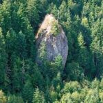
Tamanowas Rock is a remnant of deposits from an explosive volcano that stood near here about 43 million years ago; it is comprised of adakite, an uncommon type of rock that forms when subducted oceanic plate melts. Aadakite requires unusually hot conditions in the mantle, which in this case occurred during establishment of the Cascades.
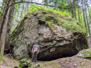
Conversely, Peregrine’s Rock is a glacial erratic named by Erik Nagle, a participant in our 2020 Great Erratic Challenge. It currently is the largest erratic documented on the Quimper Peninsula. We believe that it is greenstone (metamorphosed basalt) that originated to the north, perhaps in Canada.
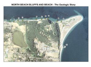
Guide to the Geology of the Bluff along North Beach, Fort Worden
Have you ever looked up at the bluffs while walking along the beach at Fort Worden and wondered how the layers formed? If so, you’ll want to use this self-guided tour of the North Beach bluff from Fort Worden to North Beach parking lot to learn about what you see.
This long-version of our recent guides describe the geology along a one mile stretch of the north shore, extending westward from Point Wilson at Fort Worden State Park. The walk is less than a mile one way.
The geologic interpretations will provide you with a concise understanding of these beautiful Pleistocene glacial deposits… Have fun and save your questions for the next Quimper Geological Society talks.
The Erratic Challenge has come to a successful end. As you may know, erratics are exotic rocks or boulders that have been brought from a distance by glacial action. For the Quimper Peninsula, that means boulders brought south about 18,000 years ago by the Vashion glaciers that originated in Canada and Northern Washington. Contestants were given a month to follow up on our challenge to find the biggest or best glacial erratics in the area, specifically on the northern Quimper Peninsula (land) north of Highways 101 and 104. Their reward was a Jefferson Land Trust hat embroidered with “Erratics Rock.” Some participants were compelled to journey farther—more power and gas to them. In the long run, 24 Intrepid Explorers, (click here)… submitted over 100 erratics that are 6 ft or longer. Erratics can be easily found all over the Peninsula, including Marrowstone and Indian Islands. They are particularly common on the beach at water’s edge or partially submerged. To be a contender, we limited the winning erratics to those on land only (sorry, otherwise we’d have to include some pretty big ones offshore). To cull the list, we tabulated the data for the 16 erratics on land that measured 10 ft or longer. Another 15+ were located partially or occasional submerged or out of the designated area. For the on-land erratics, ten are 10-15 ft long while five are 15-25 ft long. List of erratics to view/print, click here for PDF.
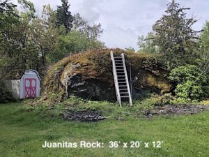
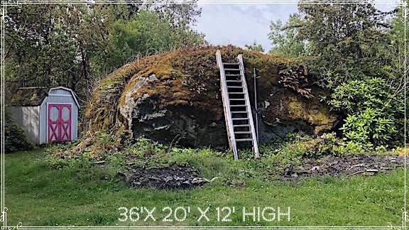
Juanita’s rock was uncovered when the Woodland Hills subdivision was developed 25-30 years ago. This erratic (36 ft x 20 ft x 12 ft high) was found by Seton Construction when they cleared one of the lots overlooking the south end of the Jefferson County airport. Petrologically (the geologic term for rock type) it’s a greenstone, which is metamorphized basalt that came from the northern Cascades or Canada’s coastal mountains. Juanita’s rock has an estimated volume of 245 cubic meters (320 cubic yards) and it probably weighs in around 700,000,000 kg (which is 700 metric tons or 756 US tons. (Math corrected 6/26/2020 by William Nesse.) Since Seton couldn’t move this whopper, it was included at no charge when Juanita Urb bought the Woodland Hills lot in 1995. She mentioned that the rock was so large that people came to see and photograph it for several years. However, it had been long forgotten until Calmar McCune mentioned it in an email. Calmar gets an Erratic Hat.
The Erratic Queen
Another notable aspect of this effort to “Extend Your Reach” was the excitement it generated. One contestant, Barbara Stahler of Coyle, spent several days roaming the County from Dabob Bay on the south to Fort Flagler on the north. She compiled and submitted a List of 60 Erratics, all with dimensions, GPS coordinates, and photographs. As ringleader of this contest, I unilaterally crown her “Queen of the Erratics” and she gets an Erratic Hat.
The Egg & I Road south of Chimacum is well known from Betty McDonald’s 1945 book about her farm, but in 2008 Phil Vogelzand and Katie McCoy bought the 20-acre parcel and started their own Egg & I Farm. Later they conceived and built the Corner Farmstand at the heart of Chimacum. So it’s fitting that one of the larger entries is the Egg & I Rock. An Erratic Hat goes to Phil Vogelzang.
Another person that we need to acknowledge is Kitty Reed, who initiated this geology group many years ago and has led numerous geo-beach walks along the bluffs of Fort Worden, from the lighthouse to North Beach. A long-time glacial-erratic fan, Kitty and her deceased husband Gerry have been watching one notable erratic on that stretch of the beach. It has a Coast and Geodetic benchmark mounted on the top of it. That’s a first as far as we know. Check it out.
Winners of Erratic Hats embroidered with “Erratics Rock”
Barbara Stahler: Submitted 60 rocks; 5 big on-land erratics Calmar McCune: Largest on-land erratic, 36 ft in Woodland Hills Kris Kiesel: 17.5 ft in Woodland Hills, landscape object Keith and Dee Norlin: Three big ones (8-16 ft) in the peace symbol field Pat and Dave Granger: 15.5 ft block of rock at Cleveland & 25th Phil Vogelzandl: 14.5 ft, Egg & I Rock, hidden in the woods Toni Evans Ziel: 12.5 ft rock off Cappy’s Trail, Quimper Wildlife Corridor
Annie Karl: 11 ft landscape object along Jackman St. in North Beach Robert Yourish: 11 ft rock at his home near Middle Point Dan Darrow: 11 ft rock near Rosencrans and Umatilla, Kathy Darrow for scale
Honorable Mentions (in water or out of area)
Ellen Cote: 19 ft erratic on North Beach Anne Seeley; 18 ft erratic on Toandos Peninsula. Renee Barron & Cass Whalen: 17 ft erratic on Toandos Peninsula. Kitty Reed: Erratic with benchmark, North Beach Adam & Chris Cray: 10 ft erratic at their Woodland Hills home Bob & Carol Middelburg: Two erratics at Port Townsend Library
Eric McRae and Kirk Steinbach: Offshore erratics, Marrowstone Island Henry Tormala Takaki (age 12?): Tamanowas Rock (nice try)
When I visited the Egg & I Farm, Doyle Clancey (the Caretaker) mentioned a giant rock he’d seen along Tarboo Creek. This was our of our search area, but what the heck, I had to check it out. OMG. You can see it from a 1/4 mile away at the back of Mark and Tami Pokorny’s farm, which is appropriately called the Valley Rock Farm (“we grow them big”). Mark and Tami (a geologist) took a keen in this knocker which the USGS had inspected back in the 60’s. It’s a greenstone (metabasalt like Juanita’s Rock) that measures roughly 40′ x 25′ x 15′, but has more than twice the volume (and weight). It’s surrounded by blackberries so it remains to be well measured, but Pokorny’s Rock is currently the LARGEST GLACIAL ERRATICon the Quimper Peninsula. Congratulations!
LATER-BREAKING NEWS
An even larger erratic was documented in July by Eric Nagle. It’s a metabasalt like many others that measures roughly 43′ x 34′ x 20′. Its located on the ridge about Tamanowas Rock and is currently the LARGEST GLACIAL ERRATICon the Quimper Peninsula. Congratulations Eric.
For an updated list of erratics, go to our Resouces page and click on List of Erratics (updated August 2020).