FRIDAY June 21, 2024 (9 AM)—REGISTRATION CLOSED
FIELD TRIP: Examine Discovery Bay’s Past Tsunami Record Using Two Contrasting Evidential Methods
There are at least two salient features of Pacific Northwest history: an extremely active geologic past, coupled with a region inhabited by indigenous peoples since “time immemorial”.
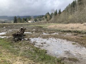
These two features share common ground at Discovery Bay on the Quimper Peninsula of Washington State. Many tsunamis have occurred at this bay over at least the past 3000 years, during which time the area was concurrently inhabited by indigenous peoples.
This field trip will examine the geologic and anthropological evidence of the occurrence of multiple tsunamis in Discovery Bay. Our field trip leaders, Dr. Carrie Garrison-Leavy (geologist) and Dr. Alexandra Peck (anthropologist), are active researchers in their respective fields, which are specific to this topic. They will lead us through an examination of the possible link between tidal marsh tsunami sedimentation and indigenous oral histories as contrasting evidential methods of recording tsunami history.
About the Speakers: Carrie Garrison-Leavy and Alexandra Peck
Dr. Carrie Garrison-Laney is a Coastal Hazards Specialist at Washington Sea Grant and a liaison to the NOAA Center for Tsunami Research. A focus of Carrie’s research has been the age and distribution of paleo-tsunami deposits with lessons learned from historical events. She earned her PhD from the University of Washington.

Dr. Alexandra Peck is professor and Audain Chair in Historical Indigenous Art at the University of British Columbia. Trained in archaeology, her research explores pre-colonial Native life, cultural change, and social interactions on the Olympic Peninsula. With extensive academic publications, she is also co-editor of Archaeology in Washington.
Carrie suggests for the wetland portion of the trip:
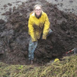
Wetland participants must come equipped with at least knee-high boots since the tsunami sediments are exposed in a tidal marsh. This will be messy but fun!!!!
“Be prepared to get muddy. You might want to bring a change of clothes and shoes to put on before getting back into your vehicle. Consider bringing a trash bag or bucket to transport your muddy things. Wear chest waders if you have them. You can get by with snug-fitting hip boots, knee-high boots, or lace up boots that can get muddy, perhaps paired with rain pants. The mud sucks loose-fitting boots and shoes right off your feet, so sometimes people wrap duct tape around the ankles of their boots to make them extra snug. Water sandals are not a good option unless they are closed toe (and tight fitting) because there are sharp things out there that will poke your toes. I recommend bringing gardening gloves to keep your hands somewhat clean and protected. In addition, bring rain gear, warm layers, water, snacks, a sun hat, sunscreen, and anything else you might need to be comfortable in a tidal marsh for a couple hours.”

 Check back again… we will soon have additional information about the lecture.
 Harold Tobin is a Professor and Paros Endowed Chair in Seismology and Geohazards and Director of the Pacific Northwest Seismic Network, at the Department of Earth and Space Sciences, University of Washington.
