2020-01-18 Jeff Tepper — Accretion of the Olympics and Birth of the Cascades
From the Accretion of the Olympics to the Birth of the Cascades: The Eocene Transformation of Washington Geology About the lecture Dr. Jeffrey Tepper showed how Port Townsend lies between two mountain belts with very different origins, the oceanic Olympic Mountains to the west and the continental Cascade Range to the east. But despite their contrasting traits, the histories of these two chains are intimately connected. He explored how the arrival of the Siletzia terrane about 52 million years ago led to a profound geological transformation of the Pacific Northwest. Over a 10 million year interval in the mid-Eocene (~54-44 Ma),… Read more2020-01-18 Jeff Tepper — Accretion of the Olympics and Birth of the Cascades
2020-02-29 Tsunami Evacuation Walk Time Maps
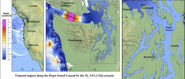
The Department of Natural Resource’s Geological Survey has released a series of Tsunami Evacuation maps for coastal areas of Washington. The Port Townsend map (2019) prints as a large poster, but we’ve made a smaller version that you can download here. Take a look and find your evacuation route if a tsunami is approaching. If its from the Big One (M 8-9) on the Cascadia Subduction Zone, you’ll have nearly two hours of response time; if its from a local crustal earthquake on the Whidby-Camino fault zone, if could be just minutes before it arrives on our beaches and bays. Get… Read more2020-02-29 Tsunami Evacuation Walk Time Maps
2020-02-29 Carrie Garrison Laney — Tsunami deposits of the Puget Sound
Tsunamis in Washington State: Evidence for local and Cascadian earthquakes Washington’s tsunami sources include the obvious Cascadia subduction zone, plus local crustal faults, tsunamigenic slope failures, and distant source tsunamis (Alaska, Japan, Chile). The longest geologic record of past tsunamis is at Discovery Bay, just 10 miles southwest of Port Townsend. At least nine tsunami deposits dating back 2,500 years are preserved as layers of fine sand in otherwise peaty tidal-marsh deposits, whereas only five Cascadia earthquakes were recorded in the estuaries of southwest Washington during that same time span. This suggests that other tsunami sources created erosive and flooding… Read more2020-02-29 Carrie Garrison Laney — Tsunami deposits of the Puget Sound
2020-05-20 Michael Machette — Geology in Our Neighborhood (JLT Recording)
Click here: https://youtu.be/jaFWQiZNv38 The Lecture (Starts at around 23 minute mark) This presentation on May 20, 2020 was made as part of Nature in Your Neighborhood, a six-part series of Zoom Lectures sponsored by the Jefferson Land Trust (add link here). It describes the general geologic history of the Quimper Peninsula during the latest Pleistocene (past 20,000 years) and Holocene (past 11, 500 years). It focuses on three themes: Glacial meltwater channels — Chimacum Valley The Bluffs Downtown Glacial Erratics with a special challenge The presentation is about an hour long and features geologic interpretation of glacial deposits in the… Read more2020-05-20 Michael Machette — Geology in Our Neighborhood (JLT Recording)
2020-05-24 Glacial Erratic Challenge
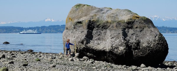
Glacial Erratic Challenge. As part of the Jefferson Land Trust’s “Extending your Reach” online lecture series, Michael Machette presented a lecture on the Glacial Geology of the Quimper Peninsula. One of the three lecture topics was “Glacial Erratics.” And the closing slides presented A Challenge and a Reward Challenge: Find the biggest erratics in our area. None under 6 ft (2 m). Small ones are too easy. Respect private property, get permission to access. Area of search: Quimper Peninsula north of Hwys 104 and 101. (This area is within the glacial limit.) Collect as many sites as you like. When… Read more2020-05-24 Glacial Erratic Challenge
2020-07-27 Results from the Glacial Erratic Challenge
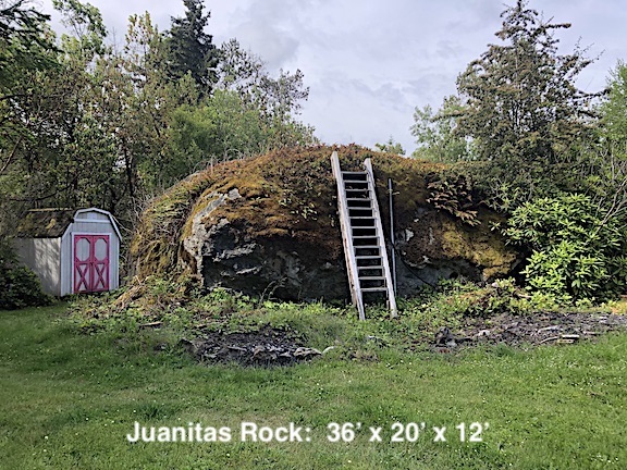
The Erratic Results are In! (slightly modified on July 27th) The Erratic Challenge has come to a successful end. As you may know, erratics are exotic rocks or boulders that have been brought from a distance by glacial action. For the Quimper Peninsula, that means boulders brought south about 18,000 years ago by the Vashion glaciers that originated in Canada and Northern Washington. Contestants were given a month to follow up on our challenge to find the biggest or best glacial erratics in the area, specifically on the northern Quimper Peninsula (land) north of Highways 101 and 104. Their reward… Read more2020-07-27 Results from the Glacial Erratic Challenge
2020-10-03 Terry Wallace — Gold: A Journey from the Big Bang to the Amazon (Zoom)
Gold—A Journey from the Big Bang to the Amazon Gold is one of the most fascinating of the 5,400 mineral species on Earth and no mineral (or metal) evokes more emotion, but gold also has an incredible scientific story: a gold nugget is made of material that was not born in our planet or even our solar system. In this talk, world-renowned geophysicist Dr Terry Wallace discusses how the metal was created, how it came to be found on Earth, and the spell it has cast over humankind. The lecture was broadcast via Zoom on Oct. 3, 2020; the recording… Read more2020-10-03 Terry Wallace — Gold: A Journey from the Big Bang to the Amazon (Zoom)
2020-10-08 Michael Machette –Your soil: it’s all about geology
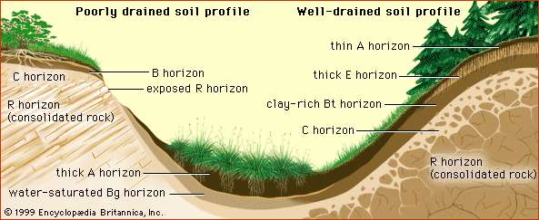
Your soil— it’s all about geology (presented by Port Townsend Master Gardeners) The lecture If you didn’t see Michael’s hour-long Zoom presentation, it will be available for 6 months on WSU’s YouTube channel (click above). Michael discussed the local geology ofPort Townsend and the larger Quimper Peninsula and geology effect on the soils in your garden. Topics included soil forming factors, the importance of and way to determine the texture of your soil, and the relationships between surficial geology and soils, with examples from Port Townsend and the Chimacum Valley. All of the soils in this region are young (less than 15,000… Read more2020-10-08 Michael Machette –Your soil: it’s all about geology
2020-11-14 Pat Pringle — Buried and Submerged Forests of the Pacific Northwest
How much we know about the Pacific Northwest’s post-Ice Age geologic events has grown rapidly in recent decades. The discovery and study of buried and submerged forests-Victims of past catastrophes, has opened the door to new understanding. Testing techniques such as Carbon 14 wiggle matching and dendrochronology (tree-ring dating) now allow more precise dating of the geological past as well. These capabilities are revolutionizing our understanding of the history, behavior, and effects of past volcanic eruptions, regional earthquakes, major landslides, and (to a limited extent) regional climate history and fluctuations. We will take a snapshot tour of some of the many locations of buried and submerged forests around… Read more2020-11-14 Pat Pringle — Buried and Submerged Forests of the Pacific Northwest
2020-12-12 Will Gallin — Geologic Carbon Sequestration in Washington State
The Subject What is carbon sequestration? What are the benefits and risks of geological carbon sequestration in Washington State? And what is technologically possible and economically feasible? We will examine these questions and explore the current state of the science. The Washington Geological Survey is part of a three-year partnership of 13 western states, stimulated by the U.S. Dept. of Energy (DOE). The member institutions, consisting of state geological surveys, universities, and national laboratories (under Dr. Robert Balch of New Mexico Tech), will identify commercially viable interstate networks between carbon emitters and potential subsurface carbon reservoirs. With this initiative as a backdrop, we will learn… Read more2020-12-12 Will Gallin — Geologic Carbon Sequestration in Washington State
Photo gallery of erratics
Here is a photo gallery showing the largest 15 erratics from our recent challenge (click here for more info about the challenge). Over 100 rocks were submitted having a minimum size of 6 feet. The largest erratic (Juanita’s rock) is 36 feet long. In addition, we’ll continue to record any new erratics that are at least 10 ft large. Click here for the current list of large erratics on the Quimper Peninsula. Click on any photo and see slideshow.