Crescent Lake Field Guide

Map from Washington Water Science Center – USGS

by James Aldrich Ph.D. – Sept. 2013

To read/print the whole Olympic Field Guide, click here…
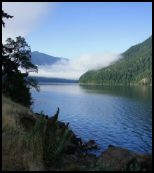
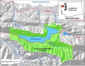
Location Details

Lake Crescent Overlook – Roadcut in Crescent Formation, Tcb unit of Tabor and Cady (1978a). Flows of black pillow basalt striking approximately east-west and dipping steeply (~850) north; dense to highly vesicular; contains microphenocrysts of clinopyroxene [Fe, Mg, Ca, Na, SiO2, and Al] and calcic to soda plagioclase [(Ca, Na) (Al,Si) AlSi2O8]. A submarine flow at Crescent Lake, just below the contact with the overlying Aldwell Formation yielded an 40Ar/39Ar date of 52.9±4.6 Ma while the base of the submarine Crescent Formation flows on Hurricane Ridge Road yielded an 40Ar/39Ar date of 45.4±0.6 Ma. These two dates suggest the Crescent Formation, while mapped as a single unit between these two locations, had more than one eruptive center (Babcock et al., 1994).

There is disagreement among investigators as to whether the chemistry of the basalt justifies separating the formation into lower and upper members. Glassley (1974) and Muller (1980) maintain that the chemistry points to two members – a lower mid-ocean ridge basalt (MORB) and upper oceanic island basalt (OIB) member. Cady (1975) and Babcock et al, 1994) argue there is no clear difference in chemistry between the upper and lower members. More work needs to be done to resolve this issue.

Fundamental to the geology of the Olympic mountains is the basalt which makes up so much of them. This is rock created at mid ocean ridges which sea floor spreading brings to continental margins where subduction is occurring, part of the conveyor belt of earth surface crust with formation in the ocean and consumption beneath continents.

Basalt is also made in oceanic islands where hot spots are burning through the ocean floor to feed volcanoes like Hawaii. Subduction wedges basalt and deep ocean sediments into the continental margin and builds out the land mass over time using slices of the oceanic material as construction material.

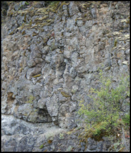
Crescent Basalt: Flows of black pillow basalt striking approximately east-west and dipping steeply (~85°) north. Pillows show that the lava was extruded onto the seafloor where it chilled rapidly into a solidified mass. This basalt dates from 53 to 45 million years ago when it rose at a sea floor spreading center. Spreading carried it continentward, and subduction jammed it into the margin of North America.

2016-10-01 Jeff & Carol Tepper: Ice Age Floods field trip

About the Field Trip

A Field Trip to Examine the Geology of the Missoula Ice Age Floods

As the last Ice Age was coming to an end, vast quantities of meltwater accumulated in ice-dammed lakes located in what is now western Montana.  Repeated failures of the ice dams resulted in a series of catastrophic floods that swept across eastern Washington between ~15,000 – 13,000 years ago.  These so-called “Missoula floods” were far larger than anything witnessed in historic times and they profoundly changed the landscape of eastern Washington.  On this long two-day trip we will examine some of the features and deposits left behind by these floods, focusing in particular on those that can help us to appreciate their enormity.  The geologist credited with piecing together the story of the Missoula floods, J. Harlan Bretz, spent over 40 years studying the evidence the floods left behind, seeking to convince a skeptical geological community that features such as the Grand Coulee were the result of catastrophic events rather than gradual erosion over a long interval of time.  As we visit many of the same sites that Bretz studied, we will focus on that one fundamental question:  “How do we know we’re seeing the aftermath of cataclysmic events as opposed to merely a long history of gradual erosion?

Saturday, October 1 – Sunday, October 2, 2016.  The trip departs from Fort Worden in Port Townsend at 7 AM and we will return to Port Townsend on Sunday evening (~ 7 PM).

Trip Leaders:  Dr. Jeffrey Tepper (Geology Professor, University of Puget Sound) and Carol Serdar Tepper (Licensed Geologist).

Group Size and Transportation:  This trip is limited to 30 participants.  We will travel together in three 10-person vans. You can leave your personal vehicle at Fort Worden and it will not require a Discover Pass.

Trip Difficulty:  No formal geologic background is required but participants should have an appreciation of geology and be in good physical condition.  Most stops will require walking short distances (less than 0.25 mile) and, in some cases, on uneven ground.  The climb to the top of Steamboat Rock (2.5 miles roundtrip, 800 vertical feet, rocky trail) is moderately strenuous but is optional. Please, no pets or minors (under 21) for logistical and liability considerations.

Lodging: We have reserved a block of rooms (held until September 1 at a motel in Grand Coulee. All participants must stay at the motel with the group. There are a variety of room configurations.  You will receive room reservation information when we have registered you for the trip. You will then have 48 hours to make your room reservation and report the confirmation number to us. Please do not attempt to make room reservations before we have registered you for the trip. Dinner Saturday will be at a restaurant near the motel. Sunday box-lunch is provided.

Trip Cost: The cost of the trip will be $60 per person.  This covers the vans, gas, Sunday box lunch, water, and the trip leaders’ expenses.  Lodging and all other meals are at your expense.

2015-09-19 Liz Schermer: San Juan Islands

About the Field Trip

GEOLOGY OF THE FIDALGO, LOPEZ, AND THE SAN JUAN ISLANDS

TRIP OVERVIEW

Day 1. Lopez Island:  

Ferry from Anacortes to Lopez Island. Three stops to see rocks and structures of the Lopez Structural Complex –a major fault zone of the San Juan thrust system. Ferry to San Juan Island in the afternoon.

Day 2. San Juan Island:

Stops at Lime Kiln Point to see rocks transported thousands of miles from the tropics, Cattle Point to see deformed sandstones and siltstones of the Lopez Structural Complex grooved by glaciation, and American Camp to see a major thrust zone.   Ferry to Anacortes.

Fidalgo Island:

Stop to see an assemblage of oceanic crust

FIELD TRIP COORDINATOR:

Jim Aldrich is coordinating the logistics (lodging, transportation, ferry schedules, etc.) for the trip and is the contact for questions.

FIELD TRIP LEADER:

Liz Shermer, professor, Department of Geology, Western Washington University, has studied and published papers on the geology of the islands.

SPACE AND COSTS
Limited Space: Space is limited on this trip to 23 persons as only five cars (each holding 5 persons) can be accommodated at certain stops. Sign-up for the trip is on a first-come basis.
Costs: A $50.00 trip fee, per person, is being charged to cover the Geology Group’s operational costs. Persons will be added the trip list on receipt of their $50.00 fee. The fee is non-refundable should one withdraw from participating. The fee does not cover the cost of lodging or meals. Lodging has been reserved on San Juan Island for Saturday the 19th. Cost for rooms are under $90.00, have full or queen beds and may be shared with another person.