2021-10-02 Ian Miller & Keith Denton — Field Trip: A decade of changes in the Elwha River as a result of dam removal

Quimper Geological Society Field Trip

October 2, 2021, Port Angeles Area

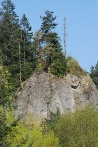
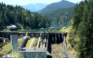
One-day field trip (car caravan) to see the Elwha River’s response to removal of its two dams 7 years ago (2014).  We’ll see the lower dam site, one of the dissected lake basins, sedimentation along the river’s mid-reach and the build out of the river’s delta. Ian Miller, our geologic guide, is with the SeaGrant program of the University of Washington, but resides in Port Angeles close to the action.  In addition, we recruited Keith Denton to talk about the main reason for the dams removal (fish)   Keith is a Fisheries Consultant and will discuss the recovery program that has brought salmon back to the Elwha River after a century.

Leaders:  Ian Miller, Coastal Hazards Specialist, Washington Sea Grant, Port Angeles
Keith Denton, Fisheries Specialist and Consultant, Sequim
Michael Machette, Quaternary Geologist (retired), Port Townsend

Objectives:  Visit ground zero of the largest dam-removal project in the world and one of the largest ecological restoration projects ever attempted. See the developing shore-line and take a tour of three important restoration sites along the Elwha River. Enjoy the outdoors and have enlightening discussions (socially distanced).

Click here to download the Elwha River field trip guide

Resource Book – Geology Underfoot in Western Washington

Dave Tucker has re-published (2019) Geology Underfoot in Western Washington. The book features several dozen field trips to exciting geologic sites in our region.

By the way, if you google search “book geology underfoot” you will see guides for MANY places in this continent.

Link to past Tucker speaking event…

Link to our list of interesting blogs including Tucker…

Wikipedia about Dave Tucker…

2019-09-20 Pat Pringle: Geology of Mt. Rainier Field Trip

Sept. 20-22, 2019:  Mt. Rainier Field Trip

Professor Emeritus Pat Pringle of Centralia College and colleagues led a 3-day trip to the Mount Rainer area to see the geology of this fantastic mountain and its geologic and environmental effects on the surrounding region.  Participants provided their own transportation and lodging (in Ashford and Packwood); we provided field trip log, a published guidebooks, experts on specific aspects of the geology and geomorphology, and a chance to see one of Washington’s three active volcanoes.

The trip started at 11 am Friday at Mud Mountain Dam Park south of Enumclaw.  We made a CCW circumnavigation of Mt. Rainer and ended up on the northeast side on Sunday afternoon, east of Enumclaw. Rain and socked in that day, but good wx for the first two days. Many of the stops were roadside, but we took several 1-2 mile hikes with 300-500  feet of elevation change.  A good time was had by all, and a true value at $50 each.

Pat Pringle

For more info, you can download the preliminary field trip route and schedule by clicking here. In addition, Pat published a guide to this area that will serve as a more comprehensive resource. Pdfs of the various chapters of the Roadside Geology of Mount Rainier National Park and vicinity, Information Circular 107 (IC-107) as well as pdfs of other publications can be downloaded via links in the Washington Geological Survey’s online catalog.

Go to this link, and then go down to the WGS publications catalog link. This catalog gets updated regularly. Suggestion, it may be easier to download the book as individual chapers, because the entire book is >300 MB.