Fidalgo Ophiolite Revisited: A chaotic assemblage of ophiolitic blocks deposited in a matrix of mudstone, sandstone, and basalt flows overlain by deep-water turbidites derived from a volcanic arc – John S. Oldow, Whidbey Island
The Lecture
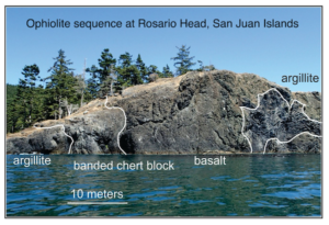
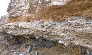
It has long been thought that an intact ophiolite had accreted to North America and was preserved on Fidalgo Island in the San Juan Islands, just north of Port Townsend. (An ophiolite is a slab of oceanic crust and underlying mantle rock.) These ophiolitic rocks are on spectacular display along the coast of Fidalgo Island, including in Deception Pass State Park, the most-visited state park in Washington. This body of oceanic crust was interpreted to have subsequently been the site of an oceanic island arc, a chain of volcanoes, with parts of the island arc’s volcanic rock also accreted. Mount Erie, the highest point on Fidalgo Island, is underlain by a body of granite that represents a magma chamber beneath one of the volcanoes. It is easy to see why Fidalgo Island has long been a major attraction for people interested in exploring complex geology.
Recently, Dr. John Oldow and his Ph.D. student David Katapody reexamined and reinterpreted the geology of Fidalgo Island and adjacent islands. Here blocks of various parts of the subduction complex and volcanic arc were deposited as sedimentary mélange composed of debris flows and rock falls carried into a basin containing mudstone, sandstone, and basalt flows. The deep basin was ultimately filled and overlapped by deep marine clastic rocks derived exclusively from the adjacent island-arc complex. The mélange and overlap succession were subsequently subducted to high pressure – low temperature conditions before being returned to the surface and imbricated along the North American Cordillera. Their work rewrites the geology of the area and calls for revising how the accreted terranes of the area have been mapped and named. The work of Oldow and Katapody is a fresh, eye-opening look at the rocks of the San Juan Islands and how they formed.
The Speaker
 John Oldow received his BS degree in geology from the University of Washington in 1972 and his Ph.D. in geology from Northwestern University in 1978. He taught geological sciences with a specialty in structure and tectonics for 40 years: at Rice University for 17 years, at the University of Idaho for 13, years and at the University of Texas Dallas for 10 years before he retired from academia in 2018. He returned home to the Pacific Northwest and lives on northern Whidbey Island. He is still active in research projects in the western Great Basin, northern Alaska and northwestern Canada, and the San Juan Islands of Washington State. He continues to consult for mineral and petroleum exploration companies and holds a position as a Research Associate at Western Washington University.
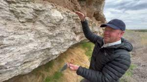
 Calcrete is a CaCO3-rich hardpan paleosol that forms in dry, stable landscapes of the world. Calcrete in eastern Washington cements a 20-m-thick interval across three geomorphic domains: Palouse Hills, Channeled Scablands, and Yakima Fold Belt. The sheet-like calcrete deposit encloses ancient Scabland flood gravels and defines a regional paleosurface that has been bent and broken by Quaternary faults. Calcrete overprints primarily lowland alluvial deposits (ancestral Columbia-Snake River floodplain) and basaltic alluvial fan gravels shed from fault-bounded ridges. Thick layers of pedogenic carbonate accumulated during the Pleistocene, between about 1.8 million years ago to about 40 thousand years ago, but older cements at somewhat deeper levels date back to ~7 million years (late Miocene). The appearance of arid-land calcrete in eastern Washington coincides with the topographic rise of the Cascade Range and establishment of a strong rain shadow east of the divide. This lecture shed new light on this lesser-known part of eastern Washington’s stratigraphy.
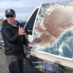 The Speaker