Geology News Notes: This came across our web desk might be of interest to you
Quimper Geological Society
Tsunamis in Washington State: Evidence for local and Cascadian earthquakes
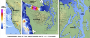
Washington’s tsunami sources include the obvious Cascadia subduction zone, plus local crustal faults, tsunamigenic slope failures, and distant source tsunamis (Alaska, Japan, Chile). The longest geologic record of past tsunamis is at Discovery Bay, just 10 miles southwest of Port Townsend. At least nine tsunami deposits dating back 2,500 years are preserved as layers of fine sand in otherwise peaty tidal-marsh deposits, whereas only five Cascadia earthquakes were recorded in the estuaries of southwest Washington during that same time span. This suggests that other tsunami sources created erosive and flooding tsunamis in Discovery Bay. The youngest tsunami deposit at Discovery Bay is probably from the 1700 A.D. Cascadia earthquake. The next older deposit is well dated at 1320–1390 A.D. However, there is no geologic evidence for a late fourteenth-century earthquake or tsunami in any of the southwest Washington estuaries, so this tsunami may represent a smaller Cascadia earthquake that was limited to the northern end of the subduction zone.
Potential tsunami sources can be tested using new high-resolution tsunami modeling for specific sites. At Discovery Bay, tsunami models show that a large Alaska-Aleutian subduction zone earthquake could cause flooding at Discovery Bay, whereas models of the Seattle fault do not. Recently published maps and video animations for a M9 Cascades subduction scenario will be shown for Port Townsend and Port Angeles.
 Dr. Carrie Garrison-Laney is a tsunami hazards specialist at Washington Sea Grant at the University of Washington and a liaison to the National Center for Tsunami Research at the Pacific Marine Environmental Laboratory at NOAA in Seattle. Carrie’s work on tsunami hazards in Puget Sound includes identifying and dating paleo-tsunami deposits, numerical modeling of tsunami inundation, and the use of intertidal paleoecology to study past tsunami events. Carrie also participates in a variety of outreach activities, including Washington’s Tsunami Roadshow. In her spare time, she helps her two daughters navigate high school and college
About the lecture
Dr. Jeffrey Tepper showed how Port Townsend lies between two mountain belts with very different origins, the oceanic Olympic Mountains to the west and the continental Cascade Range to the east. But despite their contrasting traits, the histories of these two chains are intimately connected. He explored how the arrival of the Siletzia terrane about 52 million years ago led to a profound geological transformation of the Pacific Northwest. Over a 10 million year interval in the mid-Eocene (~54-44 Ma), volcanic activity swept across the region from as far east as Montana, extensional stresses triggered faulting and formation of sedimentary basins, the Olympics were established, and volcanism in the Cascades was initiated. All of these phenomena can be linked to the accretion of Siletzia, which caused the Farallon Plate that had been subducting beneath Washington to slow, roll back, and ultimately break off. The evidence of these dramatic events is recorded in rocks we see at the surface as well as in geophysical anomalies deep in the mantle. This event was sponsored by Quimper Geological Society, an Earth Science outreach group of Jefferson Land Trust.
About the speaker
Jeff Tepper was on faculty of the Geology Department at the University of Puget Sound, he began his emeritus status in 2021. He earned his PhD from UW, where he studied the origins of granite in the North Cascades. At UPS he teaches classes in mineralogy, petrology, geochemistry, GIS, and geomythology. Most of his research projects focus on the magmatic and tectonic history of the Pacific Northwest (including Tamanous Rock), or on the geochemistry of water and sediment from Tacoma-area lakes. Visit Jeff’s website for more information: https://www.jeffreytepper.com/