Where are the Olympic Coast garnet sands coming from and how did they get there?
Washington State contains multiple beaches where garnet bearing sands are present, including the outer coast and within Puget Sound. The source of these garnets is unclear. To better understand where these garnets come from, we look inside them to investigate inclusion minerals. When garnets form in metamorphic environments, they can trap other minerals from their surroundings. These trapped minerals can give us pressure and temperature constraints to narrow down the source of the garnet. We can then compare results between garnet samples and their potential sources to their current locations. This information improves our understanding of how glaciers and rivers transported sediment during the last glaciation of the region. Our study also furthers a new technique of using garnet inclusions as tracers of where sediments originated.
About the Speakers
 Leigh Tucker is a post-baccalaureate student at the University of Washington working towards a Bachelor of Science in Geology. Her undergraduate honors research extended the work started by Marquis Richardson, comparing sands from the Puget Sound and the Olympic Coast to determine if the garnets came from the same source. She recently interned with the USGS Earthquake Science Center on the development of an automated earthquake rupture mapping tool using machine learning and unmanned aerial vehicles. Leigh plans to pursue a graduate degree in volcanology after completing her BS in June 2025. When she isn’t studying, you can find Leigh baking, hiking, or reading to her granddaughter.
 Marquis Richardson graduated from the University of Washington with a BS in Earth and Space Sciences: Geoscience. During his time there he investigated index mineral inclusions in garnet sands from Ruby and Rialto Beaches on the Olympic Coast (Washington). After graduation he hiked the Pacific Crest Trail and worked as a staff geologist for a geotechnical consulting firm before moving to restoration ecology work. He will be hiking the Continental Divide Trail over the summer of 2025 with plans to pursue graduate school after he returns.
POST Lecture emails:
 5/3/2025 (PM) Carrie Carpenter from Whidbey Island wrote an email asking about sand on the beach close to where she lives: “i live on whidbey…East Point in Saratoga Passage… garnet sands?”
Yes, these Whidbey Island sands contain garnet sands too…
Another comment from QGS member Steve Bergman Jan2026 included:
“Ruby Beach” Sands Found on Vashon Island!
We are lucky to have a QGS member put together a lesson on the beach sands of Vashon Island. Find the summary here: Vashon RubySand SteveBergman Jan2026

 Glaciers have shaped much of the Pacific Northwest’s landscape over the past 15,000 years. The Cordilleran ice sheet, repeated ice age floods, and expansive alpine glaciation have left their distinctive fingerprints on the topography of our region. Geologists and cartographers have been mapping and interpreting glacial landforms since the late 19th century. In the past decade, the Washington Geological Survey has created new maps that build upon this rich cartographic history by fusing older datasets and techniques with modern insights and technology, such as lidar.
 Daniel Coe has been making maps of the Pacific Northwest for the past two decades. He currently serves as graphics editor for the
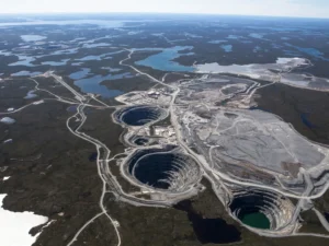
 Earth’s mantle and then are brought rapidly to the surface in CO2-rich explosive eruptions. No such eruptions have occurred in human history, but we know they occur only in the interiors of continents, where they produce narrow vertical ‘kimberlite pipes’ that are mined in Africa, Russia, and, more recently, Canada. Tiny diamonds with a completely different origin have been found in meteorites, and some of these appear to predate the formation of our solar system. Nowadays, diamonds can also be grown artificially, and these synthetic crystals are widely used in industry and, increasingly, in jewelry. For geologists, diamonds are invaluable tools for understanding the Earth’s interior.
  They are used to make tiny “anvils” that allow us to conduct high-pressure laboratory experiments that replicate conditions deep inside the Earth, and they commonly contain minute inclusions of other minerals that are our only actual samples of mantle materials from depths as great as ~400 km (250 miles). Jeff provided how and where diamonds form, offered a brief summary of how we search for them, described their history as gemstones, and detailed what they tell us about our planet’s deep interior.