When Americans think of earthquakes, they are likely to think of California. Laced with active faults and subject to frequent quakes, the state certainly stands out on national maps of seismic hazards. But the current maps also highlight seismic hazards farther north, chiefly in Washington and Oregon, which became known since the 1970s through a remarkable series of discoveries in the United States and Japan. USGS geologist Brian Atwater played key roles in these discoveries by identifying, in coastal geology, the traces of earthquakes and tsunamis going back thousands of years.
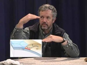
The 1980 eruption of Mount St. Helens called attention to the Pacific Northwest as a region of ongoing subduction, where one of Earth’s tectonic plates descends beneath another. The mountains provide this subduction zone with its geological name, Cascadia. Subduction zones elsewhere account for Earth’s greatest earthquakes, as large as magnitude 9. But even as recently as 1980, nobody knew whether such earthquakes should be expected at Cascadia.
Atwater, born in Connecticut in 1951, grew up in the relatively geologically sedate area of New England. After earning his bachelor’s and master’s degrees in geology at Stanford University, Atwater completed his doctorate at the University of Delaware in 1980, by which time he was already working for the United States Geological Survey. His early work, centered in the West, included studies of sea-level changes at San Francisco Bay and ice-age floods from Montana.
In 1986, his work in Washington’s Neah Bay first led him to suspect a history of previously unrecorded major earthquakes in that region, a history hinted at by Native American tales of great floods and upheavals. Such tales had led geophysicists to debate the possibility of quakes and tsunamis in Cascadia, but convincing evidence remained elusive. Atwater wondered whether the answers might be found by investigating the region’s coastal geology, leading to a hypothesis he further developed with extensive field investigations. He corroborated his findings in Cascadia with other work in known subduction zones in Japan and Chile.
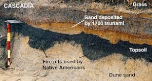
By 1987, he was ready to announce findings that would upend the mostly-accepted geological notion that, seismologically speaking, the Pacific Northwest had been a relatively quiescent region of North America. He published a paper in the journal Science that detailed how a series of major earthquakes and resulting tsunamis had left behind their unmistakable signature in the coastal sedimentary record of the region. The paper did more than startle legions of formerly skeptical geologists—it accelerated the new geological discipline of coastal paleoseismology. Building upon Atwater’s findings and using data from tree ring records from “ghost forests” destroyed by coastal submergence, scientist David Yamaguchi narrowed down the date of the most recent large Cascadian seismic event to circa 1700.
The date coincided with a tsunami that hit Japan in January of that year, which had come to be known over the ensuing centuries as an “orphan tsumani” because the cause had never been discovered. But Atwater had found the orphan tsunami’s progenitor at last. Traveling to Japan to do extensive historical research in collaboration with Japanese scientists, Atwater confirmed that a magnitude 9 earthquake in Cascadia was responsible for the tsunami that impacted Japan that year.
With the evidence that such strong earthquakes had indeed occurred in the Northwest—and undoubtedly would happen again—Atwater has become a major voice urging the adoption of preparatory measures to safeguard the population and property of Cascadia’s major cities and to plan for the inevitable “Big One” in the Pacific Northwest. In both the scientific press and in popular media, he continues to passionately advocate for earthquake and tsunami public awareness and preparedness. His efforts in public outreach and communication led to his recognition by Time magazine in 2005 as one of America’s “100 Most Influential People.”
Unlike more lab-centric sciences such as chemistry and molecular biology, or mathematical physics done on blackboards and computers screens, geology often requires getting out in the field, digging in the dirt, wading through mud, canoeing down remote streams, and traipsing through scratchy brush in insect-infested wilderness. Far from shying away from those realities, Atwater revels in them, one reason for his prominence as a field researcher who braves the elements for scientific gold. As a long-time affiliated professor at the University of Washington, he has trained and mentored a new generation of geologists and seismologists in the art and necessity of doing good science while getting one’s hands (and everything else) dirty.
Atwater is an American Geophysical Union fellow, a Geological Society of America fellow, and a National Academy of Science member. But as many of his colleagues have noted, even beyond his purely scientific contributions, perhaps Brian Atwater’s greatest award will be a legacy of saving lives by promoting greater awareness and vigilance against the threat of earthquakes and tsunamis in the United States and around the world. (Above information from the Franklin Institute as of March 2016)
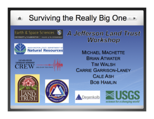
Brian has presented to the Quimper Geological Society in 2011 and again at an Earthquake Hazards Workshop in 2015. More than any local scientist, Brian has brought the hazards of a great Cascadia Earthquake to the public’s attention. He retired from the USGS recently after nearly 40 years of public service. He continues to be an Affiliate Professor at the Dept. of Earth and Space Sciences at the Univ. of WA, (Updated Oct. 2021)