2024-04-20 Ralph Haugerud – Glacial Landscape of Puget Sound

Post-Mortem of Southern Cordilleran Ice Sheet

The Lecture: Post-mortem of the southern Cordilleran Ice Sheet

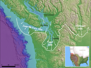
Death of an ice sheet can have many causes, as shown by retreat of the southern Cordilleran Ice Sheet about 15,000 years ago. East of the Cascades, the margin of active south-flowing ice retreated north as less snow fell and more melted. West of the Cascades, the Juan de Fuca lobe of the ice sheet appears to have floated away in response to rising sea level, perhaps without a proximal climatic cause. Collapse of the Juan de Fuca lobe diverted ice from the Puget lobe, which consequently stagnated at its margin and rapidly melted back. Later Sumas ice readvance in the Fraser Lowland may reflect stabilization of the remnant ice sheet by grounding as local sea level fell, followed by climate-driven retreat.

For a more detailed abstract, please see Ralph Haugerud’s detailed abstract Jan2024.

The Speaker 

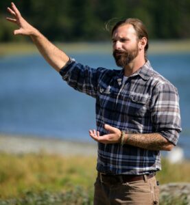
Ralph Haugerud is an exceptional geologist. Many describe him as a structural geologist and geologic mapper interested in the evolution of the Pacific Northwest, and many know about his popularity from being featured on Nick Zentner’s programs.

Ralph is a Seattle native, with BS and MS degrees from Western Washington University and a PhD from the University of Washington. He began his career looking deep in the Earth’s crust at gneiss and tonalite in the North Cascades, moved on to study turbidites, then glacial till, and now spends much of his time looking at lidar topography. He is employed by the USGS and lives in Wenatchee, Washington.

2023-12-09 David Brownell—Drainage evolution of the Dungeness River

The Lecture

David Brownell, Executive Director of the North Olympic History Center, discussed the shifting “paleochannels” of the Dungeness River and established an environmental and anthropological framework to reach a better understanding of the history of the Dungeness River since the end of the last ice age.

During the last glacial epoch, the Dungeness River discharged its alluvium and built a large depositional complex that extends from the mountain front at Bell Hill north to and including the Dungeness Spit, an intriguing feature on its own (see side image).

We looked at archaeological, geological, and other evidence to “recreate” the landscape of the North Olympic Peninsula as it adapted to changes in climate, biology, and other factors.

The Speaker 

David Brownell moved to Washington in 2015 to take a position as the Cultural Resources Specialist for the Jamestown S’Klallam Tribe. During his time with the Jamestown Tribe, he was responsible for government-to-government consultation with federal, state, and local agencies regarding impacts to cultural sites; curation of the Tribe’s artifact and archival collections; repatriation of ancestral remains and artifacts; education, outreach, and much more. He also worked extensively with Jefferson Land Trust’s conservation team to secure and protect the Tamanowas Rock Sanctuary, and to educate and train Land Trust staff members.

As Executive Director of the North Olympic History Center, he manages a collection of thousands of photos, artifacts, books and more. We are currently digitizing our collections and making them available to the public at www.nohc.catalogaccess.com, as well as planning exhibits and programs for 2024. On the side, I have a small farm in Sequim where I raise goats, chickens, and lots of fruits and veggies.


2023-11-14 Shake Map — Simulation of 7.4 M earthquake on the South Whidbey Island fault

If you live in the Puget Sound, you might want to look at the attached U.S. Geological Survey shake map and shake scale models resulting from a 7.4 event on the South Whidbey Island Fault.  The full article with a description of projected damages is found at https://earthweb.ess.washington.edu/gomberg/ShakeMap/ShakeMaps.html