About the Field Trip
FIELD TRIP TO NODULE POINT, MARROWSTONE ISLAND
The Jefferson Land Trust’s Geology Group will lead a walking tour of Nodule Point, which is on the southeastern coast of Marrowstone Island. The trip will be based on a field guide that Dave Tucker of Western Washington University has on his NW Geology Field Trip blog. Please download and read this guide before joining the trip (see registration info to left).
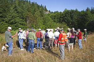
FIELD TRIP: The field trip will be both lay and technically oriented, so although a basic knowledge of geology would help, we’ll have geologists along to explain the features we’ll be seeing and touching. We’ll walk 0.7 miles from E. Marrowstone Road to Nodule Point and then back. You’ll have to be agile enough to get up and down the bluff via a narrow-steep staircase, but the walk is rather easy.
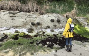
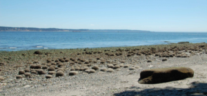
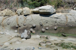
TRIP OVERVIEW: Nodule Point: why it’s there—basalt dike, baked zone, and weathering. Evidence for faulting after dike emplacement. The Scow Bay sandstone, a local building stone Nodules within the sandstone and on the beach. The overlying Vashon (latest Pleistocene) glacial till.
- To download a recent guide, click this link
LOGISTICS: 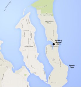 When and Where. Meet by 10:30 am at the home of Greg Lalish, 1101 E. Marrowstone Road. Drive/bike about 600 ft to the east on his access road, where we’ll park on his property. Carpool with others if possible. Then we’ll hike east on Hoyt Road (Private) and drop down to the beach via a private staircase. Bicyclists can go directly to the access point at 501 Hoyt Road (arrive at 11:00 am).
Access: Trip will be along a private road (Hoyt) and through private property. Adults and children over 12 only please, no dogs.
Space: Trip size is limited by parking and staircase access. Max. will be 50 or less. Sign- up for the trip is on a first-come basis, bicyclists get priority (because of parking issues).
No cost, just become an avid supporter of the Jefferson Land Trust. Bring: Wear footgear that protects your ankles. Hat, light jacket, water, bag lunch, camera, notepad, etc. We’ll go no matter what the weather, so be prepared. We’ll eat lunch on the beach.
 Advisors of the Geology Groups will run the rain-canceled beach walk on Marrowstone Island on Sunday, July 22, to see the Eocene and Pleistocene sections at Nodule Point, located near the southeast end of the island. This walk is timed for the low tide and participation will be limited (by parking spaces) to 50 persons.
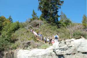 Walk. It’s about 2.4 miles from the East Beach lot to Nodule Point. Probable walking time, one way, is 1.5 hour–or more if we see interesting things in route. Arrival time at Nodule Point should be about 12 am (lunch). Collecting and/or defacing the outcrop is discouraged: please take nothing but pictures, and leave nothing but footprints. Wear your sturdy walking shoes/boots. Bring clothing for the weather, a pack, water, camera, and your own lunch. No bathroom facilities are available beyond the parking lot. We’ll plan to return to the parking lot by about 2:30 pm and be at Chimacum HS by about 3:00 pm.