About the Talk
STABILIZING PORT ANGELES’ COASTAL LANDFILL
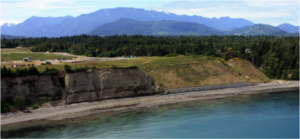
In 1947, the City of Port Angeles created a 25-acre dump at its shoreline, between Ediz Hook and the Elwha River. Over the ensuing 60 years, the site evolved into a 70-acre sanitary landfill with numerous waste containment cells.
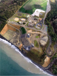 Since closure in 2007, and for about 5000 years before that, wave action at the beach site has been continuously eroding the 135-foot tall feeder bluffs. In June 2011, a small exposure of garbage from one of the seaside landfill cells was observed hanging over the edge of the bluff. Further erosion could easily have resulted in a large release of garbage onto the beach since there were only eleven to fifteen feet of native bluff between the eroded face and a 60-foot deep pit of municipal solid waste.
Kathryn Neal will review the geologic setting, bluff retreat rates and the sediment contribution of the bluffs to Ediz Hook, the history of public works construction at the site, wave energy and beach morphology studies that the City conducted, and summarize the design alternatives that the City considered before deciding to relocate the landfill.
In her time with Port Angeles, this has been one of the largest and most significant projects she has been involved in, and arguably the most unique. The project, which was completed this year at a cost of about $21.3M, protects the environment, will last for many decades and was successfully accomplished within the financial constraints of a small city.
About the Speaker
Kathryn Neal, P.E. is Civil Engineering Manager with the City of Port Angeles. Kathryn has a Bachelor of Architecture and Civil Engineering from the University of Washington and has been a practicing Professional Engineer since 1994. She grew up in Port Angeles and was thrilled to be able to move back to the Olympic Peninsula about 15 years ago. When she has time off, she enjoys hiking, kayaking, reading, and imagining alternate realities.
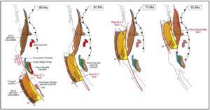
 Accreted terranes have a different geologic history than the bodies of rock adjacent to them and are separated from their surroundings by major faults. The Crescent Formation of the Quimper Peninsula, for example, is part of a large accreted terrane that underlies much of the coastal Pacific Northwest. The Crescent Terrane originated as piles of basalt which erupted from the sea floor and in some places built broad oceanic islands. This basalt, along with oceanic sediment, was then shoved against and accreted to the continent. Deep thrust faults separate the Crescent Terrane from terranes that had accreted earlier to the Pacific Northwest. Subsequently, the younger oceanic crust has been added seaward of the Crescent Terrane. Each piece of accreted crust is separated from the others by thrust faults, and the subduction zone continues to shift westward as younger terranes are added to the edge of the continent.
 About the Speaker