About the Talk
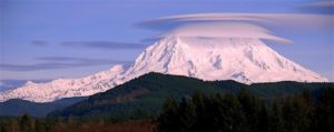
Mt. Rainier—New Information about the Volcano in Our Backyard
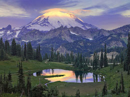
Mount Rainier has been called the most hazardous volcano in the United States. It’s an active volcano with a seismic pulse and hissing fumaroles in its east summit crater; some crater water is at the 86° boiling point for that elevation. Recent research shows that this sleeping giant has erupted for more than half a million years and that it has had more than 40 eruptions since glaciers retreated from the Puget Lowland about 15,000 years ago. It has generated great lahars (huge volcanic debris flows) that buried forested river valleys for tens of kilometers. Some lahars flowed all the way to Puget Sound and, along with later sedimentation, greatly modified the Puget Lowland landscape. The volcano’s glaciers have been retreating in recent years, and as they do, rivers heading on Mount Rainier have been moving sediment quickly downstream, resulting in an annual drumbeat of alluviation in lowland areas. Pat will discuss how geologists are continuing to study and monitor the volcano and the potential impacts of future eruptions.
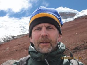
 About the Speaker
Mr. Pringle is Assoc. Professor of Earth Science at Centralia College, Washington. He was with Washington DNR’s Division of Geology from 1990 to 2005 and with the U.S. Geological Survey’s Cascades Volcano Observatory from 1982 to 1990. Pat studies volcanoes, earthquakes, landslides, and debris flows, commonly using radiocarbon and tree-ring analysis to establish the history of past geologic events. He is the author of books on the roadside geology of Mounts St. Helens and Rainier. His Mount Rainier book won “Best Guidebook Award” at the Geological Society of America’s 2009 Annual Meeting.
 Myths from many cultures around the world contain descriptions of phenomena or events that bear a striking resemblance to natural disasters including floods, earthquakes, volcanic eruptions, tsunamis, and meteorite impacts. Geomythology is an emerging discipline that combines geology, archaeology, mythology, and history to investigate the possibility that some of these mythical “stories” may in fact be garbled accounts of actual events that occurred in the distant past. There is strong evidence that some myths originated over 7,000 (and possibly up to 40,000) years ago. Thus a major challenge in geomythology is to see through the changes these stories underwent as they were passed down orally over hundreds of generations. In this talk we will examine the origins of the Great Flood story, analyzing the Biblical and Mesopotamian versions as well as possible linkages to catastrophic flooding of the Black Sea. We will also discuss Plato’s account of the sinking of Atlantis and several stories that appear to have originated with earthquakes and tsunamis. Included among the latter are legends from the Pacific Northwest that feature battles between the Thunderbird and the Whale, a motif now recognized as a tsunami metaphor.