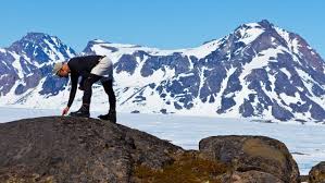
2025-01-11 Paul Bierman – When the Ice is Gone
THE LECTURE Cold War Science and Engineering Today Reveals Greenland’s Fragility in an Overheating Climate QGS hosted Paul at 4 PM on January 11, 2025 Paul’s lecture focused on how Greenland, a remote arctic island, holds in its ice enough water to raise sea level over six meters (20 feet). That is enough to flood every major coastal city and displace up to half a billion people. As he discussed, until recently we knew very little about the past comings and goings of this massive ice sheet. Through the lens of climate science, environmental history, and the stories… Read more2025-01-11 Paul Bierman – When the Ice is Gone
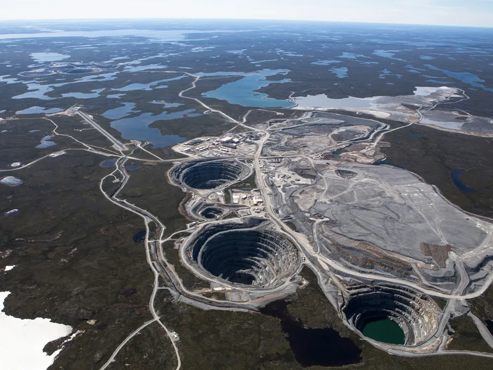
2025-02-15 Jeff Tepper – Diamond: A Multifaceted Gem
LECTURE – Diamond: A Multifaceted Gem QGS hosted former QGS advisor and emeritus professor, Jeff Tepper on February 15, 2025. Jeff’s lecture described that diamonds have been revered as precious stones for over 2000 years, yet they are composed simply of carbon, one of the most common elements on Earth. He explained their rarity arises from the fact that they form at extreme pressures deep in the Earth’s mantle and then are brought rapidly to the surface in CO2-rich explosive eruptions. No such eruptions have occurred in human history, but we know they occur only in the interiors of continents,… Read more2025-02-15 Jeff Tepper – Diamond: A Multifaceted Gem

2025-03-08 Dan Coe – Mapping Our Glacial Legacy
The Lecture: Mapping the Glacial Legacy of the Pacific Northwest Glaciers have shaped much of the Pacific Northwest’s landscape over the past 15,000 years. The Cordilleran ice sheet, repeated ice age floods, and expansive alpine glaciation have left their distinctive fingerprints on the topography of our region. Geologists and cartographers have been mapping and interpreting glacial landforms since the late 19th century. In the past decade, the Washington Geological Survey has created new maps that build upon this rich cartographic history by fusing older datasets and techniques with modern insights and technology, such as lidar. Using both historical and modern maps,… Read more2025-03-08 Dan Coe – Mapping Our Glacial Legacy

2025-04-12 Dan Muhs – Tectonic Uplift in the Pacific Northwest
The Lecture Subduction-related late Quaternary tectonic uplift and sea-level change in the Pacific NW and around the Pacific Rim This was a Zoom-only lecture. Quimper Geological Society welcomed Dan Muhs, an emeritus USGS geologist. He provided marine terraces as evidence of tectonic uplift along the Pacific Ocean plate. In 1979, Seiya Uyeda and Hiroo Kanamori introduced a tectonic model with two end members of a subduction-boundary continuum: the “Chilean” type (shallow dip of the subducting plate, great thrust events, compression, and uplift of the overriding plate) and the “Mariana” type (steep dip of the subducting plate, no great thrust events,… Read more2025-04-12 Dan Muhs – Tectonic Uplift in the Pacific Northwest

2025-05-03 Leigh Tucker and Marquis Richardson
Where are the Olympic Coast garnet sands coming from and how did they get there? Washington State contains multiple beaches where garnet bearing sands are present, including the outer coast and within Puget Sound. The source of these garnets is unclear. To better understand where these garnets come from, we look inside them to investigate inclusion minerals. When garnets form in metamorphic environments, they can trap other minerals from their surroundings. These trapped minerals can give us pressure and temperature constraints to narrow down the source of the garnet. We can then compare results between garnet samples and their potential… Read more2025-05-03 Leigh Tucker and Marquis Richardson
2025-07-25 and 26 – QGS North Olympic Peninsula Field Trip
Eocene Bedrock Geology of the Northern Olympic Peninsula: Arrival of the Siletzia Oceanic Terrane, Washington WHEN: July 25-26, 2025 (Friday and Saturday) Quimper Geological Society (QGS) had an exciting two-day field trip on Friday, July 25, and Saturday, July 26, 2025, to the North Olympic Peninsula, led by led by Professor Erin Donaghy (University of Nevada, Las Vegas, sedimentologist and field geologist) with Carol Serdar Tepper (retired geologist, Washington Department of Ecology) and Jeff Tepper (Professor emeritus, University of Puget Sound) as co-leaders. We looked at rocks related to docking of the Siletzia oceanic terrane, including volcanic and sedimentary units… Read more2025-07-25 and 26 – QGS North Olympic Peninsula Field Trip

2025-09-13 Tom Badger – Hazards and Highways: Troubles for the NW Olympic Peninsula
The Lecture Hazards and Highways: Troubles for the NW Olympic Peninsula State Route 112 is the sole access road for the northwestern Olympic Peninsula and the remote communities situated along the Strait of Juan de Fuca, west of Port Angeles. Particularly unfavorable geology underlies the western half of this road and this, combined with steep topography and an exceptionally wet winter climate, make it one of the most landslide-afflicted highway corridors in the state. Landslides and lowland flooding impact travel most winters, causing short duration closures of one or both lanes and necessitating persistent maintenance efforts. On a longer cycle… Read more2025-09-13 Tom Badger – Hazards and Highways: Troubles for the NW Olympic Peninsula

2025-12-06 David B. Williams – Exploring History and Nature in the City and beyond…
The Lecture – Exploring History and Nature in the City (Seattle) Quimper Geological Society welcomed back our friend David B. Williams, author, naturalist, and tour guide on December 6, 2025. David B. Williams speaks about his two new books: Seattle Walks and Wild in Seattle. In his talk, David discusses how urban dwellers can get to know their city better by getting outside, walking, observing, and paying attention. He shares some of his adventures including birding at 60 mph, the pleasures and discoveries to be made by going back to the same location repeatedly, and how to date a 1100-year-old earthquake…. Read more2025-12-06 David B. Williams – Exploring History and Nature in the City and beyond…