Nan Evans of KPTZ and local geologists, Jeff Tepper and Michael Machette, explore two significant rocky outcrops in Eastern Jefferson County – Tamanowas Rock and Peregrine Rocks, both just northwest of Chimacum. To download the field trip guide that this interview was based on, click here.
The interview is for Nature Now, a weekly radio broadcast on KPTZ 91.9 MHz. Because Nan got so many interesting tidbits, the interview will be broadcast in two parts and each will be recorded as MP3s and be available if you can’t hear the broadcasts:
Show #587: Hard Rock Geology in Eastern Jefferson Country, Park 1
Broadcasts Oct. 5 at 12:30 PM, Oct. 7 at 5:30 PM, Oct. 8 at 12:30 PM
Listen in to learn how Tamanowas Rock was formed, what it can tell us about the ancient landscape of our region, why Tamanowas Rock is important to indigenous peoples, and what is being done to protect it. The recorded broadcast is available on KPTZ’s Nature Now page.
Show #591: Hard Rock Geology in Eastern Jefferson Country, Park 2 Broadcasts Nov. 2 at 12:30 PM, Nov. 3 at 5:30 PM, Nov., 5 at 12:30 PM
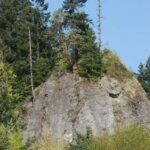
Exploring Peregrine Rock, a glacial erratic, gives listeners a chance to consider the impacts of glaciation on Eastern Jefferson County and to ask just where did the rock come from and how did it get here?
Geology of Tamanowas Rock and Peregrine’s Rock, Chimacum, WA
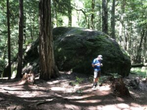
Tamanowas Rock
On Friday, July 8, 2022, five of our QGS geologists led a 4-mile, 4-hour hike from HJ Carroll County Park near Chimacum to the Tamanowas Rock Sanctuary, then up on top of Tamanowas Ridge to see Peregrine’s Rock.
This 4-mile hike is vigorous, steep, and rough in parts and is tailored to agile citizen scientists who are already knowledgeable about geologic principles and vocabulary.
Subjects discussed on the field trip include the glacial history of the Quimper Peninsula (specifically Chimacum Valley), glacial erratics on the Peninsula, and the geology of the underlying Eocene volcanic rocks that form Tamanowas Rock. This feature is a special part of the story and a sacred place of the S’Kallum people.
Tamanowas Rock is the remnant of an explosive volcano that erupted about 43 million years ago. It is comprised of adakite, an unusual type of lava that forms under anomalously high temperatures when a subducted oceanic plate starts to melt.
Conversely, Peregrine Rock is a glacial erratic named by Eric Nagle, a participant in our Great Erratic Challenge two years ago. It currently is the largest erratic we have found on the Quimper Peninsula (see Great Erratic Challenge under Resources in the menu bar.
The field trip guidebook, which is 13 pages and well illustrated (pdf), was edited after the field trip and is now available. There is a 2023 version (June 2023), see more recent field trip notice.
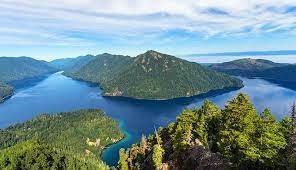
Earthquakes, Rock Avalanches, Displacement Waves, and Turbidites: The Amazing Holocene Sedimentary Record from Lake Crescent, Clallam County, Washington
The Lake Creek–Boundary Creek fault zone lies below Lake Crescent, a deep, glacially carved lake on the north side of the Olympic Peninsula, west of Port Angeles. This fault zone includes a system of structures that reveals at least 56 kilometers (35 miles) of late Pleistocene to Holocene surface rupture. New data from the sediment cores taken from the lake’s bottom document four ruptures along the fault zone. Those seismic events triggered several large rockslides along the slopes adjacent to ancestral Lake Crescent that split the lake into two: Lake Crescent and Lake Sutherlund. After this separation, each lake established its own drainage system to the Strait of Juan de Fuca. Over time, the salmonids in each lake have developed genetic differences that now make them distinct new species.
Karl explained the tools and processes he and his colleagues used to understand the past ~7200 years of lake history by examining sediment cores. He also shared their thoughts on the calculated risk of a ~Mw 6.5-7 earthquake in the next 100 years… and the outcome of salmon speciation.
Karl Wegmann is a local guy! Well, he grew up on the north side of the Olympic Peninsula, where his parents still hike the trails. He received his Ph.D. (2008) Earth and Environmental Science, Lehigh University, Bethlehem, PA; and M.S. (1999) Earth and Planetary Sciences, University of New Mexico, Albuquerque, NM; starting college career with a B.A. (1996) Geology, Whitman College, Walla Walla, WA; and best of all he graduated from Port Angeles High School (1992).
Karl currently is an Associate Professor of Geology at the Department of Marine, Earth, and Atmospheric Sciences, North Carolina State University (2015-present) and is Faculty Fellow – Center for Geospatial Analytics there as well (2017 – present).
His previous work as a geologist, no doubt, helps his students become geologists with practical experiences. He worked as a geologist with Washington State Geological Survey (1999-2004). He has more than 70 research publications, including peer-reviewed journal articles, geologic maps, and landslide hazard assessments. Karl is fully engaged in academia and is Primary Mentor/Advisor for 8 Ph.D. and 7 M.S. graduate students at N.C. State who have conducted research on the Olympic Peninsula of Washington State, Colorado, New Mexico, North Carolina, Oregon, Greece, Mongolia, and Mars; he is also co-creator of the HazMapper.orgplatform for global, open-source, and publicly available natural hazard detections via cloud computing. And to top life off, Karl has just finished the post of the 2021-2022 Chair of the Quaternary Geology and Geomorphology Division of the Geological Society of America.