The Geology of Southwest British Columbia’s Sea to Sky Highway
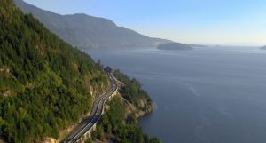
British Columbia’s Sea to Sky Highway (Highway 99, connecting Vancouver to Squamish, Whistler, and Pemberton) provides a journey through the geology of British Columbia’s Coast Mountains, where relief from valley floors to summits is commonly 1500-2000 m. The highway follows the steep fjord wall of Howe Sound past waterfalls, debris flow-prone gullies, rockfall hazards, glacial erosion features, and the Britannia Beach copper mine (operational until 1974), before arriving in Squamish. The town of Squamish sits at the head of Howe Sound and is located near the 700 m cliffs of the granitic monolith, the Stawamus Chief, as well as the dormant volcano, Mount Garibaldi, and a debris fan comprising mainly volcanic material from Mount Garibaldi, including material that was originally deposited supraglacially before being remobilized when the Cordilleran ice sheet disappeared. North of Squamish, the Sea to Sky Highway climbs from a floodplain and winds its way through the Cheakamus River canyon, with views of the mountains and glaciers of the Tantalus Range to the west. The vertical cliffs of the Barrier mark the site of a mid-nineteenth century landslide from an andesite lava flow that ponded against remnants of the Cordilleran ice sheet during the waning stages of the Fraser Glaciation. At Brandywine Falls, the Brandywine River cascades over a stack of basaltic lava flows and drops 70 m into a canyon. A series of lava flows of Cheakamus basalt next to the highway show evidence for eruption beneath or beside ice. In Whistler, the gondolas to the top of the ski slopes allow for broad views of the geology of the Coast Range, including the volcano, Mount Cayley, located 15 km west of Whistler (but not visible from lower elevations). North of Whistler, Nairn Falls, located 1.5 km from the highway, has numerous large potholes and other features eroded by water. The town of Pemberton lies about 60 km southeast of the volcano, Mount Meager, which in 2010 was the source of the largest historic landslide in Canada (about 49 million m3). Although Mount Meager occupies only 2.5% of the area of the Lillooet River watershed, it is the source of 25-75% of all the sediment deposited in the Lillooet River valley during the Holocene. Three prehistoric debris flows from Mount Meager, including one contemporaneous with its 2350 BP eruption, reached as far as currently inhabited areas of Pemberton. This eruption, the only known explosive Holocene eruption in Canada, left an ash layer that today can be traced as far as central Alberta, more than 500 km downwind.

If you are considering a road trip in nearby Canada, this might be the one for you. You’ll see how glaciation, erosion, the sea, volcanoes, and man have shaped this landscape. In addition, the Looney is cheap (80 U.S. cents), the people are friendly, and the landscapes are fantastic.
Click here to download the full tour brochure…
About the Speaker
Melanie Kelman completed her Ph.D. at the University of British Columbia in 2005, where she studied the Mount Cayley volcanic field. She first became in geology as a child, when her father, a rock collector, took the family to quarries, gravelly lakeshores, and mine dumps around western Canada and the U.S. Melanie started work in October 2007 with Natural Resources Canada in Vancouver. She currently devotes her time to volcanic-hazard research, volcano emergency planning, and the preparation of educational materials. If volcanic unrest were to occur again in Canada, she would play a major role in monitoring, hazard assessment, and eruption forecasting.
 Jim Aldrich has a Ph.D. from University of New Mexico (1972), taught geology at several colleges, and was a structural geologist for 20+ years at Los Alamos National Laboratory in New Mexico. Jim served as a staff member and Group Leader of Earth and Environmental Sciences. He has conducted investigations on low-temperature geothermal projects in Arizona and New Mexico; Los Alamos Hot Dry Rock Project; geothermal investigations in Honduras; state of stress in the crust of southwestern US; and Rio Grande rift. Project Manager for Environmental Restoration Project of Los Alamos.