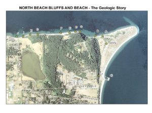
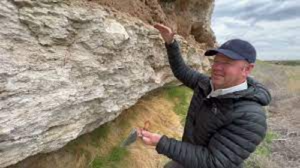
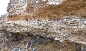
Guide to the Geology of the Bluff along North Beach, Fort Worden
Have you ever looked up at the bluffs while walking along the beach at Fort Worden and wondered how the layers formed? If so, you’ll want to use this self-guided tour of the North Beach bluff from Fort Worden to North Beach parking lot to learn about what you see.
This long-version of our recent guides describe the geology along a one mile stretch of the north shore, extending westward from Point Wilson at Fort Worden State Park. The walk is less than a mile one way.
The geologic interpretations will provide you with a concise understanding of these beautiful Pleistocene glacial deposits… Have fun and save your questions for the next Quimper Geological Society talks.
The Lecture: Soil-climate evidence for timing of the Cascade uplift and creation of its rain shadow
Calcrete is a CaCO3-rich hardpan paleosol that forms in dry, stable landscapes of the world. Calcrete in eastern Washington cements a 20-m-thick interval across three geomorphic domains: Palouse Hills, Channeled Scablands, and Yakima Fold Belt. The sheet-like calcrete deposit encloses ancient Scabland flood gravels and defines a regional paleosurface that has been bent and broken by Quaternary faults. Calcrete overprints primarily lowland alluvial deposits (ancestral Columbia-Snake River floodplain) and basaltic alluvial fan gravels shed from fault-bounded ridges. Thick layers of pedogenic carbonate accumulated during the Pleistocene, between about 1.8 million years ago to about 40 thousand years ago, but older cements at somewhat deeper levels date back to ~7 million years (late Miocene). The appearance of arid-land calcrete in eastern Washington coincides with the topographic rise of the Cascade Range and establishment of a strong rain shadow east of the divide. This lecture shed new light on this lesser-known part of eastern Washington’s stratigraphy.
The Speaker
Skye is a field geologist who specializes in mapping, paleosols, and geomorphology. His work focuses on the interplay between tectonics, topography, and climate. Skye received his BSc. in Geology from Whitman College and his MSc. from the University of Wyoming. He has been a Soil Scientist for the Colville Confederated Tribes and taught Geosciences at Boise State University.
Currently, Skye is mapping the surficial geology of the Mission Valley in northwest Montana and sorting out the geomorphic history of calcretes in Eastern Washington. Skye’s hobbies include woodworking, nordic skiing, and motor-cycles. Skye is married to Hilary, manager of the Grizzly Bear Program for the U.S. Fish and Wildlife Service. They live with their hound dog, Lucy, in northwest Montana.
Nan Evans of KPTZ and Seattle Naturalist David Williams, discussed “A Sense of Place – What is it?” This is a prelude to David’s March 18th lecture entitled “Secrets of Seattle Geology—Connections of the human story and the geology story.”
The interview was delivered for Nature Now, a weekly radio broadcast on KPTZ 91.9 MHz. The interview was recorded as a MP3 file and broadcast three times preceding David’s March 18, 2023 lecture for the Quimper Geological Society:
Show #610: David Williams—A Sense of Place: What does that mean?
Broadcast on March 15 at 12:30 PM; March 16at 5:30 PM; and March 18 at 12:30 PM
 Calcrete is a CaCO3-rich hardpan paleosol that forms in dry, stable landscapes of the world. Calcrete in eastern Washington cements a 20-m-thick interval across three geomorphic domains: Palouse Hills, Channeled Scablands, and Yakima Fold Belt. The sheet-like calcrete deposit encloses ancient Scabland flood gravels and defines a regional paleosurface that has been bent and broken by Quaternary faults. Calcrete overprints primarily lowland alluvial deposits (ancestral Columbia-Snake River floodplain) and basaltic alluvial fan gravels shed from fault-bounded ridges. Thick layers of pedogenic carbonate accumulated during the Pleistocene, between about 1.8 million years ago to about 40 thousand years ago, but older cements at somewhat deeper levels date back to ~7 million years (late Miocene). The appearance of arid-land calcrete in eastern Washington coincides with the topographic rise of the Cascade Range and establishment of a strong rain shadow east of the divide. This lecture shed new light on this lesser-known part of eastern Washington’s stratigraphy.
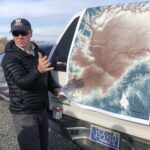 The Speaker