For the Tamanowas and Peregrine Rocks field trip, use the link below to download the guidebook (slightly revised from 2022 version). Please print a copy for your use on the trip: the figures and photographs will be particularly useful. Thanks All. Dee Norlin, registrar.
On Saturday, July 8, 2023, several QGS geologists led a 4-mile, 4-hour hike (12 PM—4 PM) from HJ Carroll County Park near Chimacum to the Tamanowas Rock Sanctuary, then up on top of Tamanowas Ridge to see Peregrine’s Rock. The elevation gain on the walk is about 300 ft. This is a repeat of our 2022 trip and includes a 13-page illustrated guidebook.
The upper part of the trail is moderately difficult but slow paced and the hike is tailored to agile citizen scientists who are knowledgeable about basic geologic principles and vocabulary. Subjects to be discussed include the glacial history of the Quimper Peninsula and Chimacum Valley, glacial erratics on the peninsula, and the geology of the underlying Eocene volcanic rock that forms Tamanowas Rock, which is a special part of this story and a sacred place of the S’Kallum people. Allie Taylor of the Jamestown S’Kallum Tribe described the history of the site and its importance to the Tribe.
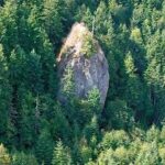
Tamanowas Rock is a remnant of deposits from an explosive volcano that stood near here about 43 million years ago; it is comprised of adakite, an uncommon type of rock that forms when subducted oceanic plate melts. Aadakite requires unusually hot conditions in the mantle, which in this case occurred during establishment of the Cascades.
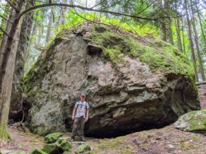
Conversely, Peregrine’s Rock is a glacial erratic named by Erik Nagle, a participant in our 2020 Great Erratic Challenge. It currently is the largest erratic documented on the Quimper Peninsula. We believe that it is greenstone (metamorphosed basalt) that originated to the north, perhaps in Canada.
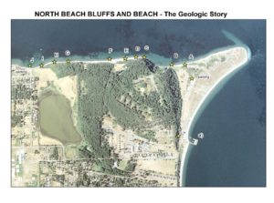
Guide to the Geology of the Bluff along North Beach, Fort Worden
Have you ever looked up at the bluffs while walking along the beach at Fort Worden and wondered how the layers formed? If so, you’ll want to use this self-guided tour of the North Beach bluff from Fort Worden to North Beach parking lot to learn about what you see.
This long-version of our recent guides describe the geology along a one mile stretch of the north shore, extending westward from Point Wilson at Fort Worden State Park. The walk is less than a mile one way.
The geologic interpretations will provide you with a concise understanding of these beautiful Pleistocene glacial deposits… Have fun and save your questions for the next Quimper Geological Society talks.